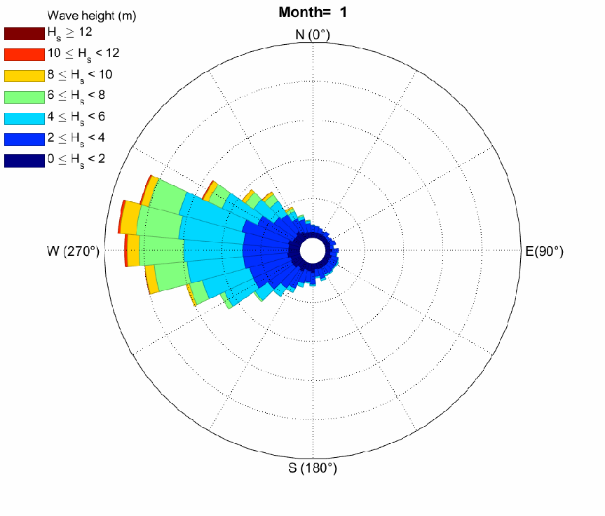
Mencoba mengunduh data hujan dari TRMM


another short post!

data hidrologi di Indonesia termasuk yang susah didapat, well, walaupun sebenarnya kita punya cukup banyak jaringan ARR, atau pencatat data hujan sih. Kalau diminta sesuai prosedur juga kemungkinan besar akan diberikan kok. 🙂

Anyway, kali ini saya mencoba menggunakan data hujan dari TRMM, karena rentangnya panjang, dan data type nya memudahkan untuk pengolahan berikutnya. Walaupun, belum tentu beneran akan saya pakai juga, tp mari kita lihat…

Saya pasang link downloadnya dulu saja ya. Untuk lengkapnya di sini: https://pmm.nasa.gov/data-access/downloads/trmm. Di halaman tersebut diberi pilihan jenis data yang biasa kita pakai. Misalnya saya menyukai data berjenis netcdf, maka akan dibawa ke halaman downloadnya: ini.

Nah sekarang baru download ya, belum tahu kualitas datanya seperti apa. Tunggu ya, saya usahakan posting lagi tentang ini.

Wind and Wave Reanalysis Dataset


This will be another short post.

There are times when we need to understand the characteristic of wind and/or wave climate around an area, but unfortunately, there is no wave buoy available there. We call such location as “poor-data area”. Luckily, there are other options, and one of those is to use the reanalysis data. Reanalysis data is a way to reproduce climate data, such as wind, air pressure, SST, etc. In the process, it also includes data assimilation. Go check the links in the references for detail.

ERA-Interim, is one of the reanalysis products, developed by ECMWF as the successor of ERA-40. It has 1×1 degree resolution, 6-hourly. Many studies have said that this dataset is quite good for climate studies. ERA-Interim provides the significant wave height, direction, and also wave period. However, unlike the ERA-40 which separates both swell and wind waves, ERA-Interim combines the two.

10-metre U and V wind components are available, representing zonal and meridian wind respectively. In order to get the speed and direction, just calculate those with simple Pythagoras Theorem. Check this page for more detail:  http://colaweb.gmu.edu/dev/clim301/lectures/wind/wind-uv

Downloading ERA-Interim is easy, if we only need daily records in a few months, we can just go to this site, register, sign in, and download. It is also possible to modify the spatial resolution and area limit. Spoiler alert, it has INDONESIA listed as an option. If we need a longer data period, we can also try to “automatically” download it using ECMWF API Client. Check this page for detail.

Let me display some data sample:

upper panel: ERA-Interim vs wave buoy.
lower panel: WW3 Hindcast vs wave buoy.

monthly

References:

Pengaturan “Regional and Language” pada Windows 8


Warning yang tampil ketika format perangkat tidak sesuai

Ketika hendak memakai software HEC-RAS, sering kali saya mengingatkan untuk mengecek format “Regional and Language” pada Windows yang dipakai. Hal ini untuk menyamakan format yang dipakai oleh HEC-RAS (dan juga software HEC yang lain) dengan perangkat yang kita gunakan. Terutama untuk perangkat dengan format Bahasa Indonesia, karena perbedaan penggunaan “koma” dan “titik” pada ribuan dan desimal apabila dibandingkan dengan format English (US) yang dipakai HEC-RAS. Continue reading “Pengaturan “Regional and Language” pada Windows 8″

SCS Dimensionless Unit Hydrograph


Okey, it’s been so long since i didn’t write anything in this “anything” web blog, since i pretty busy on doing anything. I am now living in Japan, by the way. Yea, i think i am kind of adjusting my daily life, due to time difference (that now we’re having night time longer, which means my praying time is also different than it used to be). Ah, by the way, this morning i’d like to talk about hydrology to memorize what I’ve learnt before coming to Japan (I am now studying coastal engineering).

What I’d like to discuss is about SCS Dimensionless Unit Hydrograph, which is one of the approaches to synthesize the hydrograph in a watershed, when there is no information about the discharge in it. The unit hydrograph itself, simply defined by the hydrograph which is resulted from a 1 mm precipitation in 1 hour. Ah, I’ve written about this here.

One of good sources of hydrology online manual is here , in the txdot online manual, the unit hydrograph is defined as:

“A direct runoff hydrograph produced by 1 unit of excess precipitation over a specified duration. For example, a 1-hour unit hydrograph is the direct runoff from one unit of excess precipitation occurring uniformly over one hour.” (source)

The SCS Dimensionless Unit Hydrograph is pretty popular in Indonesia, especially when the discharge data is very limited (well, maybe because in most cases it is limited). Otherwise, another approach, such as HSS Gamma-1 (well-suited in Java island- was developed in Java) will be applied.

Before calculating this dimensionless unit hydrograph, the following parameters need to be obtained: Continue reading “SCS Dimensionless Unit Hydrograph”